By Perfecto T. Raymundo, Jr.
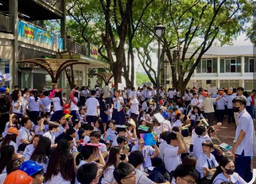
MARIKINA CITY — The local government of Marikina City held on Monday (Oct. 20) a city-wide simultaneous earthquake simulation drill participated by around 150,000 residents to prepare them for the strong quake expected to hit Metro Manila or what was dubbed as “The Big One”.
“The Big One” refers to a projected magnitude 7.2 (or higher) earthquake along the West Valley Fault near Metro Manila — a high-impact hazard scenario that scientists say could cause widespread destruction.
Aligned with Mayor Maan Teodoro’s commitment to safeguard the city’s people, the local government focused on a “family-based” and “community-based” earthquake drill wherein everyone in the city —government offices, schools, homes, businesses, and other establishments —took part in the activity that seeks to strengthen community-building and resilience among the people.
Mayor Maan said that approximately 100,000 individuals joined from schools, and an additional 50,000 participants represented communities and the private sector.
“Nasa 150,000 ang total ng nag-participate sa ating city-wide earthquake simulation drill—100,000 mula sa schools, samantala nasa 50,000 naman sa communities and private sector,” she said.
”Ang kaligtasan ng lahat ay tungkulin ng bawat isa. Dapat lagi tayong sama-sama at tulong-tulong at buong komunidad. Ito ang tinatawag natin na whole-of-community approach sa iisang layunin —- alagaan ang buhay at kaligtasan ng bawat taga-Marikina,” she added.
Mayor Maan emphasized that it is vital to conduct these citywide earthquake drills, not only to inform, but to help instill a sense of urgency, discipline, and bayanihan among the people, especially since parts of the city rest on the West Valley Fault Line—a major hotspot for possible earthquake impacts.
“Ang number one priority ng lokal na pamahalaan ay ang kaligtasan at kapakanan ng lahat ng taga-Marikina. Every year naman tayong nagsasagawa ng mga earthquake drill sa pamahalaang lungsod, at mga paaralan. Pero dahil sa sunod-sunod na earthquakes na nararamdaman sa bansa, mahalagang mas lalo pang palakasin ang kultura ng kahandaan, disiplina, at pagtutulungan ng mga komunidad sa oras ng sakuna,” Mayor Maan said.
As part of the earthquake drill, Mayor Maan inspected the city’s assets to be used in the event of a disaster, including ambulances, fire trucks, City Disaster Risk Reduction and Management (DRRM) vehicles, as well as the Command Posts and Field Hospitals that will be set up.
The mayor also assured that the city is equipped with adequate manpower and urban search and rescue tools and equipment in the event of a disaster such as a vibroscope (an instrument used for observing and tracing vibrations) that can aid in detecting victims trapped under rubble.
The Marikina City Disaster Risk Reduction and Management Office (CDRRMO) has identified some of the following safe zones in the city in case of calamities like earthquakes:
District 1:
Brgy. Barangka – UBB-FVR Road, Barangka Baseball Field, Loyola Cemetery
Brgy. IVC – C5 Access Road corner E. Abello, Major Dizon Road
Brgy. Jesus Dela Peña – Manila Bay, Provident Riverside
Brgy. Kalumpang – Ground Golf Area, Barangay Hall Grounds
Brgy. Malanday – Golden Valley Open Space, Park Land Open Space
Brgy. Sta. Elena – River Park, Freedom Park, Plaza delos Alcaldez, SNR Access Road
Brgy. San Roque – Chestnut Open Space; Midtown Phase 1, 2, 3 Open Space; San Roque Elementary School Open Space
Brgy. Sto. Niño – Sto. Niño Baseball Field, Federal Land Open Space, Marikina Sports Park, Robinsons Open Space, Gil Fernando Highway, Homeowners Drive corner JP Rizal Open Space
Brgy. Tañong – Provident River Side, Loyola Cemetery
District 2:
Brgy. Concepcion Uno – Trevi Open Space, Bayan Bayanan Avenue, Soliven Street Greenheights
Brgy. Concepcion Dos – Marikina Hotel, Katipunan Street; Rancho Estates 1, 2, 3, 4 Open Space
Brgy. Fortune – Red Cross Open Grounds, Boys Town Open Grounds
Brgy. Marikina Heights – Liwasang Kalayaan, Marist Open Space, St. Scholastica’s Academy Inside Parking Space
Brgy. Parang – Parang Play Grounds, Parang Elementary School Open Grounds
Brgy. Tumana – Farmers I, Iwahig, Woodrich Village Open Space, LGV Open Space
Brgy. Nangka – St. Mary Open Space, Bagong Sibol Open Space, Kabayani Road
Marikina DRRMO Chief Dave David said the safe zones identified by their Office are merely general areas that the public can access when an earthquake hits. However, residents are urged to identify other safe zones that are nearer to their places of residence.
“Bawat pamilya, i-identify na ang pinakamalapit na open spaces. Ang mga in-identify namin na safe zones, general areas sila. Hindi naman obligado pumunta kung malayo,” David said.
Prior to the earthquake drill, Mayor Maan led a coordination meeting on Oct. 16 with representatives from the local government’s various offices and departments, national agencies, and other stakeholders to ensure that the activity is done safely, effectively, and in an organized manner.
“Ginagawa natin ang mga paghahandang ito hindi para manakot, kundi upang maging handa. We can never be ready enough, ngunit tungkulin nating gawin ang lahat ng ating makakaya,”
Mayor Maan said. ###


